The U.S. Army Corps of Engineers is conducting a three-year feasibility study on the Tar Pamlico River Basin with a series of public involvement meetings to gather community input. The first of six events will take place virtually for the Franklin County/Louisburg area on Mar. 22, 2021, according to information from Franklin County Cooperative Extension Director Charles Mitchell.
Each of the meetings will consist of a 30-minute presentation followed by a question-and-answer session, according to a written statement from the Corps’ Pittsburgh district. The meetings are organized by geographic region and will be held from Mar. 22-31. More information about the study and how to access the meetings can be found on the district’s website: www.lrp.usace.army.mil/Missions/Planning-Programs-Project-Management/Tar-Pamlico-Feasibility-Study/.
The Corps’ Pittsburgh district, in collaboration with N.C. Department of Environmental Quality, is doing the study to develop flood risk-management alternatives for the river basin. The $3 million study began in April 2020.
Each meeting is 1.5 hours from 6 to 7:30 p.m. Access the WebEx platform at https://usace1.webex.com/usace1/j.php?MTID=m00ce03770c09508b30d3a7d9f851d5d5, To join by phone, attendees can call 1-844-800-2712 and use the access code 199-053-6905.
The study is being made in conjunction with federal disaster funding that North Carolina received following recent hurricanes, namely Hurricane Florence in 2019 and Hurricane Matthew in 2016.
The study, scheduled to be completed in April 2023, will produce recommendations to reduce flood risks and damage caused by flooding – from structures like floodwalls and levees to natural and nature-based measures like wetland and floodplain storage.
In response to recent flooding that occurred as a result of Hurricanes Matthew (2016) and Florence (2019), North Carolina received funding through the 2019 Additional Supplemental Appropriations for Disaster Relief (H.R. 2157) for a feasibility study to assess and recommend actions that reduce flood risk and increase resiliency within the Tar-Pamlico River Basin.
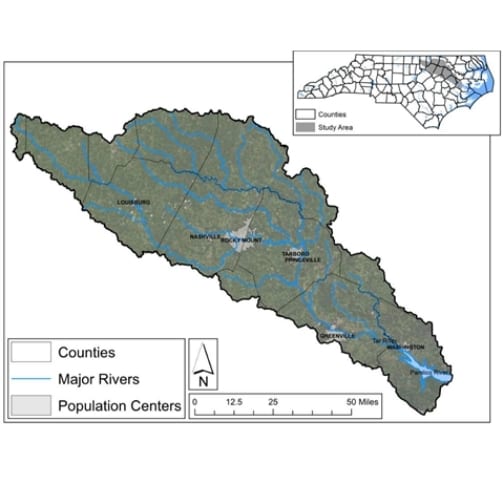
The Tar River Basin begins in the piedmont of North Carolina and extends 215 miles southeast through the Coastal Plan and flows to the Pamlico Sound estuary. The basin covers about 6,100 square miles. The study encompasses all or part of 13 counties, including Franklin County. In addition to Louisburg, the study focuses on the other five major population centers in the basin: Rocky Mount, Greenville, Tarboro, Princeville and Washington, NC. Although much of Washington is situated downstream, it also is affected by river flooding.
Many communities within the basin have experienced major recurring flood events over the past 25 years associated with Hurricanes Fran (1996), Floyd (1999), Matthew (2016)—each of which ranking among the most destructive storms in state history and representing among the top four floods of record for major population centers within the basin. Recurring flooding within the basin results in considerable economic damages to homes, businesses, industry, and public infrastructure. For example, Hurricane Matthew is estimated to have caused over $110M in damage to residential, non-residential, and public structures. Inundation of structures and roadways (i.e., reduced access to critical services and recovery aid, inundation of occupied vehicles) also results in increased life safety risks both during and following flood events.
The public can submit comments via email to lrp.plan.enviro@usace.army.mil or through the electronic comment form at www.lrp.usace.army.mil/Missions/Planning-Programs-Project-Management/Tar-Pamlico-Feasibility-Study/. Comments can also be submitted by mail to the U.S. Army Corps of Engineers Pittsburgh District Planning and Environmental Branch, 1000 Liberty Avenue, Pittsburgh, PA 15222. Comments must be submitted or postmarked no later than April 23.
(Credit for the graphic to Planning & Environmental Branch, U.S. Army Corps of Engineers, Pittsburgh District)


