Updated Tuesday, Sept. 11 at 12:30 p.m.
WIZS will be bringing you updates on Hurricane Florence as new information is received. Please check the WIZS website, Facebook page and listen live to WIZS 1450 AM and 100.1 FM for updates throughout the week. The latest briefing from the National Weather Service can be found any time by clicking here.
Information is provided courtesy Brian K. Short, director of Henderson-Vance County Emergency Operations.
(Click here for WIZS audio of this Story.)
With Hurricane Florence now only a few days away from us, our preparation efforts are now in full swing. As you can see from the latest weather briefing from the National Weather Service, this is a powerful storm that is expected to bring tremendous rainfall and damaging winds to our area of NC.
Widespread power outages are likely due to falling trees and wind. There is tremendous potential for widespread flooding and flash flooding as well. At this time, we are anticipating the tropical storm force winds to reach us late Thursday evening, but that could certainly change as the system gets closer to us.
We will be having a responder briefing which will include City and County government personnel on the apparatus floor of Henderson Fire Department Station 1 located at 211 Dabney Drive in Henderson. The briefing will begin at 3 p.m. tomorrow (Wednesday). Representatives from all responder agencies are strongly encouraged to attend.
Additionally, we are planning on recommending that a local Proclamation of a State of Emergency be put in place at the conclusion of tomorrows responder briefing. It will remain in place throughout the storm.
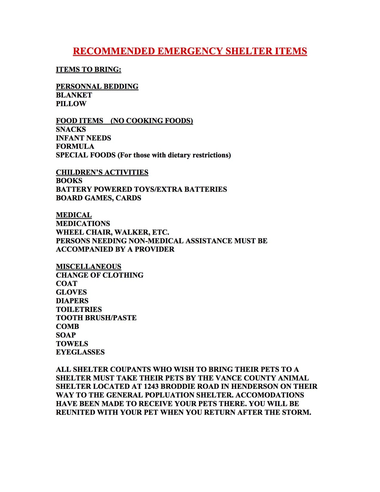
At this time we are planning to open a single, centrally located shelter at Eaton Jonson’s Middle School, located at 500 N. Beckford Drive in Henderson. We may adjust the opening time slightly as the storm gets closer to us but for now, we will open the shelter at 9 a.m. on Thursday. Below is a list of shelter items that every shelter occupant MUST bring with them to the shelter. We will do limited feeding at the shelter but will not be supplying personal items or any other items that occupants might have forgotten, so please refer to the list and read it carefully.
We are particularly concerned for residents who live in mobile/manufactured homes. We are expected to have tropical storm force winds in our area, which can cause significant damage, especially to smaller structures. We are therefore encouraging those residents who live in mobile homes to report to the shelter.
If you are a resident that does not have a way to the shelter, then please reach out to our office and we will do our best to arrange it with KARTS. They are willing to provide limited transportation services if anyone absolutely does not have another way to get there. We are encouraging residents who do not have transportation of their own to reach out to family members and neighbors first. This will ensure that they are available to those who absolutely do not have any other means of travel. If you have a need to transport a pet using KARTS, they will not transport it unless it is secured in an animal crate.
For those who have pets they wish to bring to the shelter, they must bring their pets to the Vance County Animal Shelter located on Brodie Road in Henderson. You will need to leave your pet there and then report to the general population shelter. You will be reunited with your pet after the storm. If you have a crate for your pet you must bring it with you to the shelter.
We will also be announcing our shelter openings utilizing our CODE RED community alert system, radio, print and social media, so please follow us on Facebook.
I cannot emphasize enough how important it is to take the time to prepare before the storm’s arrival. There is still time, so please use the attached as a guide. Remember, if this is a significant impact across the state (and it is believed that will be the case,) it could take days for any significant help to reach us. Therefore we strongly encourage everyone to be 72 hours self- sufficient.
Further updates will be forwarded along as they are received.


