Kansas Animal Rescue Organization Provides Assistance to Granville

-Press Release, County of Granville

Weather conditions across the state led to some unexpected assistance in Granville County this week as a Kansas animal rescue group provided relief to the animal shelter.

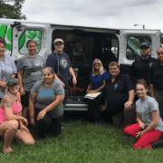
In an effort to assist those impacted by Hurricane Florence, Unleashed Pet Rescue and Adoption of Mission, Kansas – with assistance from Polk County SPCA of Livingston, Texas and Paws4Life of Shreveport, Louisiana – reached out to North Carolina animal shelters who were at or near capacity, arriving with transport units to take animals back to safer areas.  According to Granville County Animal Control Director Matt Katz, there was room for several more animals on the return trip. This was a welcome relief locally, as kennels were already pressed for space before the storm even made landfall on our coast.

Over the weekend, several more pets had been surrendered to the Granville County shelter and no more kennel space was available, Katz explains. When volunteer Roxanne Blackburn was contacted by Sherry Davis with the Polk County SPCA about pulling animals on their way out of North Carolina, the offer couldn’t have come at a better time.

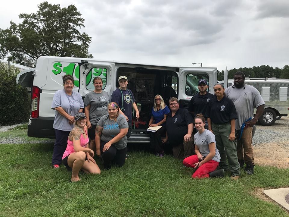
Granville County’s Animal Shelter’s save rate is 80 to 90 percent, Katz noted, but the “tough decisions” sometimes have to be made. Not this time, however, as 26 animals were rescued.

Unleashed Pet Rescue is a licensed, nonprofit animal shelter that works to save the lives of rescued pets, pulling them to safety. The organization works to find homes for pets of all ages, health, temperaments and history, giving each animal an opportunity for a better life. During Hurricane Harvey, Unleashed Pet Rescue was an integral part of the animal rescue efforts along the Gulf Coast, as well as offering assistance during other emergencies across the nation.

Katz says that this will be the first time all year that the shelter has had this many open kennels.

“These folks also pulled dogs from Franklin and Vance Counties on their way out of the state,” Katz said. “This may lead to another avenue for placement of our dogs.”

Katz credits Roxanne Blackburn for taking the initiative and “jumping on this opportunity,” and asks anyone interested in the welfare of local animals to thank these groups for their assistance.

“We are grateful to Roxanne for all her help in this, and ask everyone to please take a moment to thank these groups on their Facebook pages. This opens up so many opportunities for us, and we couldn’t be more grateful.”

Granville County Logo

Update to Granville Co. Road Closures; Three to Remain Closed Indefinitely

-Information courtesy Lynn Allred, Public Information Officer/Grants Coordinator, County of Granville

Update on Road Closures – Wednesday, September 19

After an assessment of Granville County roads by the Department of Transportation yesterday, several will remain closed indefinitely, until long-term repairs can be made. These roads are Community Road, Smart Road and Enon Road. If traveling along these areas, please make plans to detour.

Aaron Church Road is still being evaluated by the DOT, due to extensive flooding. There may be other roads in the county that have not yet been reported. Drivers are urged to move with caution and to report any additional road issues to the Granville County Sheriff’s office at (919) 693-3213.

Franklin County Logo

US-1 River Basin Near Franklin/Vance Co. Line Flooded; Tar River Rising

-Information courtesy Kristen G. King, Clerk to the Board, County of Franklin

Emergency Services Director Jeff Lewis has issued the information below following a recent update on roadways from the North Carolina Department of Transportation:

  • There is approximately two feet of water flowing over the one-lane bridge on Green Hill Road near the Franklin/Granville County line.
  • The US-1 river basin is flooded near the Franklin/Vance County line.
  • The Tar River is approximately five to six feet below flood stage in Louisburg and continues to rise.

Citizens are encouraged to move any property you may have located in an early flood-prone area. Emergency Management will continue to monitor the river gauge located in Louisburg.

Granville County Logo

Six Granville Co. Roads Currently Closed Due to Flooding

-Press Release, County of Granville

After torrential rains in the area, six Granville County Roads have been closed by the N.C. Department of Transportation due to hazardous driving conditions. Residents traveling in these areas should expect to be detoured onto safer roadways until conditions improve and/or roadwork has been completed.

Affected roads are Aaron Creek Church Road, Tom Hunt Road, Enon Road and Tar River Road, which will be assessed by DOT later today.

Closed due to washed-out pavement are Community Road and Smart Road.

Drivers in these areas should plan for extra travel time, due to detours, and are urged to use extreme caution.

*WIZS Note – After consulting with Emergency Management, Granville County Public Schools (GCPS) made the decision to operate on a two-hour delay for all students and staff Tuesday morning. According to GCPS, this decision was made based on the high water and flooding of local roads.

Amis Chapel Baptist to Host ‘Family Fun Day’ at Oxford’s Camp Oak Hill

— courtesy Granville County Chamber of Commerce | Ginnie Currin, Executive Director ~ 919-693-6125 ~ ginnie@granville-chamber.com

Camp Oak Hill and Retreat Center, 1528 Oak Hill Rd., Oxford, will be the site of a Family Fun Day event on Saturday, September 22, 2018, from 10 a.m. until 2 p.m.

Hosted by the Young Adults of Amis Chapel Baptist Church, the event will feature food, fun and fellowship.

For more information, please contact Erica Frazier at (919) 482 0087.

(This is not a paid advertisement)

Boyette, Thompson Warn of Cyberattacks During Hurricane Florence

-Press Release, NC Department of Information Technology

State Chief Information Officer Eric Boyette and State Chief Risk Officer Maria Thompson are urging North Carolinians to be cautious of cybercrime before, during, and after Hurricane Florence.

Cybercriminals take advantage of natural disasters such as hurricanes to solicit personal information illegally and to take advantage of vulnerable infrastructures, disaster victims and volunteers by phishing. Phishing is when a criminal sends out an email, text message, or even a phone call pretending to be a reputable and legitimate source in order to obtain personal information such as credit card and Social Security numbers.

“Be cautious and stay vigilant,” said State Chief Risk Officer Maria Thompson. “Let’s ensure one disaster does not lead to another. Phishing threats are real. Cybercriminals will use every tactic in their arsenal to deprive citizens of their information and ultimately their financial assets.”

Take these steps to prevent being taken advantage of by cybercriminals:

  • Carefully look at email and web addresses since cybercriminals will make them look as legitimate as possible, often using variations of spellings. The URL may have a different domain, such as .gov instead of .net.
  • Do not click on links in emails from anyone unless you know and have verified the sender of the email.
  • Take time to look at the sender’s email address. Do not click on any links until you are certain the organization is real. Check the organization’s website for its contact information and use sites such as www.charitynavigator.org to verify a charity organization.
  • Make sure all of your anti-virus software is up-to-date and you’ve enacted the anti-phishing software provided by your email client.
  • Phishing emails and phone calls may also try to pose as official disaster aid organizations such as FEMA. A true FEMA representative will never ask personal banking information, Social Security number, or registration number.

“We all need to be mindful of the value of the data we have and use every day,” said Eric Boyette, State Chief Information Officer and Secretary of the Department of Information Technology. “Too many people are vulnerable during natural disasters and it is imperative to take necessary precautions to protect yourself. Think of it as preparing an emergency kit for your personal data.”

For more information about the North Carolina Department of Information Technology, visit our website or follow us on Twitter, Facebook, LinkedIn, YouTube, and Flickr.

National Weather Service

Hurricane Florence Updates – Sept. 13

Updated Thursday, Sept. 13 at 3 p.m.

WIZS will be bringing you updates on Hurricane Florence as new information is received. Please check the WIZS websiteFacebook page and listen live to WIZS 1450 AM and 100.1 FM for updates throughout the week.

The latest briefing from the National Weather Service can be found by clicking here. The forecast – including rainfall amounts, wind speeds and storm direction – is remaining steady from earlier today.


Updated Thursday, Sept. 13 at 10:30 a.m.

We should begin to feel the effects of the storm late this evening and tonight with conditions gradually worsening overnight and into tomorrow. They have increased our rainfall potential slightly but, other than that, nothing much has changed.

We have now officially decided to open the emergency shelter at Eaton Johnson Middle School located on Beckford Drive in Henderson at 5 p.m. today. Please DO NOT arrive early as no one will be there and the school will likely be locked until that time.

We are using our CODE RED system to get this message out to all of our citizens this morning. If you are not already signed up to receive messages on that system, please visit our web page at www.vancecounty.org/EM and click on the Emergency Alert System link to sign up. This system will be used to issue important notices prior to and after the storm’s impact.

We will be activating the Emergency Operations Center at 5 p.m. this evening and will begin 24-hour EOC operations at that time. As of now, we are at Readiness Level 1, which is our highest level in preparation for the storm. The 911 Center will be overstaffed as of 11 a.m. today and will remain that way throughout the storm. We are expecting the communications center to be extremely busy during the storm, so we are asking residents NOT to dial 911 for general questions to ensure that true emergency calls are able to get through.        

Please “like” Vance County Emergency Operations on Facebook to stay up to date on what is happening with the storm. We will also continue to forward along all relevant information as it is received.

Stay Safe.

——————————————————————————————————————————————————

Updated Thursday, Sept. 13 at 9 a.m.

Hurricane Florence is approaching the coast and will slow today, and make landfall early Friday along the southern North Carolina coast, then slowly meander southwest into and across South Carolina. Confidence is HIGH that the event will occur; MODERATE confidence in expected impacts.

Strong sustained winds and gusts expected on Friday, likely persisting into the weekend. Strongest gusts expected across the southeastern coastal plain of NC. Flash and eventually river flooding likely beginning this evening and persisting through the weekend and into early next week. A risk for short-lived and weak tornadoes as the rain bands push ashore this evening through Saturday afternoon.

YOUR PREPARATIONS SHOULD BE IN PLACE NO LATER THAN MID-DAY TODAY!

Three Key Points

1. Hurricane Warning now in effect for Sampson and Wayne Counties. Tropical Storm Warning for Cumberland, Harnett, Hoke, Johnston, Lee, Moore, Nash, Richmond, Wake and Wilson counties.

2. Prolonged, life-threatening inland flooding event from heavy rain is expected across much of southern and eastern N.C.

3. Dangerous winds will also result in downed trees which will likely culminate in widespread and prolonged power outages.

For a much more detailed breakdown of the current forecast, including expected wind speed and rainfall amounts in our area, visit the National Weather Service website by clicking here

NC Coop Extension

Public Invited to Attend ‘Gathering of Gardeners’ Workshop

-Information courtesy Paul McKenzie, Agricultural Extension Agent, Vance/Warren Counties, NC Cooperative Extension

The gardening public is invited to attend a “Gathering of Gardeners: Practical Strategies for Gardening in Challenging Times and Conditions” on September 22, 2018, 9 a.m. to noon. Gardeners in Warren County and surrounding areas can learn about straw bale gardening, rain barrels and more at this workshop sponsored by the Extension Master Gardener℠ volunteers.

Participants can also get their gardening questions answered from a panel of Master Gardener volunteers. The event will be held at Buck Spring Park near Lake Gaston, located at 217 Nathaniel Macon Dr. Registration is $10 in advance or $12 at the door. All the details are available at https://warren.ces.ncsu.edu/ or by calling 252-257-3640.

Granville County Logo

Annual ‘Business & Industry Appreciation Day’ to Offer Networking Opportunities

— courtesy Granville County Chamber of Commerce | Ginnie Currin, Executive Director ~ 919-693-6125 ~ ginnie@granville-chamber.com

Granville County Economic Development, in partnership with the Granville County Chamber of Commerce and the Vance-Granville Community College Small Business Center, will present its annual ‘Business and Industry Appreciation Day’ on Thursday, September 27 from 4 until 6 p.m. The event, held at the Granville County Expo and Convention Center (4185 Highway 15 South in Oxford), will provide opportunities for participating businesses and manufacturers to network and to learn more about the services and resources available in the area. A brief program will also be held, including remarks to recognize the contributions made to the county by local employers.

Organizations, agencies and businesses offering any type of service or program beneficial to other businesses/industries in the county  – meeting space, training, office supplies, technology, finance, insurance, etc. – are invited to set up a display area to share their information with those in attendance. Registration is required and there is no charge to participate. Reservations will be taken until September 24.

Held annually for more than 10 years, Business and Industry Appreciation Day was initiated to celebrate the achievements of local business owners and the industrial decision-makers and employees who enhance the quality of life in Granville County.

“This event just keeps getting bigger and better,” said Harry Mills, Economic Development Director for Granville County. “Our businesses and industries continue to grow and expand and are quickly becoming a force in the Research Triangle region.”

The event is free and open to the public. Refreshments will be provided.

To reserve space at this year’s Business and Industry Appreciation Day event, contact Lynn Cooper at the Granville County Economic Development Department at 919-693-5911 or lynn.cooper@granvillecounty.org.

Families Living Violence Free

Families Living Violence Free Offices Close at 12:30; Dial 911 for Immediate Help

Information courtesy Peggy Roark, Sexual Assault Advocate & PREA Coordinator, Families Living Violence Free

Families Living Violence Free offices will close today, September 13, at 12:30 p.m. and be closed tomorrow, Friday, September 14, all day as well.

If you are in a domestic violence or sexual assault situation and need immediate help, please call 911.

Our crisis lines will be open 24/7 – English 919-693-5700 or Spanish 919-690-0888

Please take precautions and stay safe during the storms.