National Weather Service

Black Ice, Wind Chills the New Concerns Jan 4-6

(Click here for the latest briefing from the NWS.)

From the National Weather Service, a winter weather advisory remains in effect for the WIZS area of Vance, Granville, Warren and Franklin Counties until 7 a.m. Saturday for icy roads, black ice, hazardous travel conditions and dangerous wind chill values.

A winter weather advisory for black ice means dangerous travel from unseen ice as well as compacted snow on the road.  You are urged to be cautious while traveling both during the day and at night because high temperatures are not suppose to be above freezing through the period, with overnight lows in the single digits and wind chill values at or below zero at times.

Exposure to these wind chills can cause frostbit in as little as 30 minutes and could lead to the beginning stages of hypothermia.  Animals can be negatively affected as well.

Fresh Year, Fresh Start in 2018

— courtesy Maria Parham Health

Ask anyone what their New Year’s resolution is and chances are they’ll mention a determination to eat healthier. While many of us may consider a renewed focus on healthy eating as a way to make up for the rich indulgences of the holiday season or as a pathway to fit more comfortably into that favorite pair of jeans, healthy eating comes with even greater rewards. It can reduce our risk of illnesses like heart disease, diabetes and cancer; and it can help boost our energy, sharpen our memories and stabilize our mood, leading to a noticeable improvement in our overall health.

If you’re embarking on a path to healthier eating this year, here are some tips to help make it a little easier to make healthy food choices all year long.

Slow and steady wins the race. Changing the way you eat overnight can be daunting. Instead, make one or two healthy changes each week – drinking fewer soft drinks one week, perhaps eating a salad with dinner each night the next week. Rather than making a sweeping change that can be hard to sustain, you’ll be building and maintaining healthy habits that last.

Make a plan. Plan ahead so that you can control what and how much you are eating. Choose a day of the week to spend some time preparing a batch of healthy meals that you can package up, refrigerate or freeze and heat up throughout the week. “Meal prep” can free up your time for other pursuits during the week and help eliminate the stress that comes with “What do I want for lunch?”

Get back to basics. Stock up on healthy recipe basics like olive and canola oils, beans, brown rice, whole wheat pasta, fresh and/or frozen fruits and veggies, unsalted nuts, fresh and dried herbs and spices, and lean chicken and fish.

Fill your glass. With water, that is. Soda, energy drinks and sports drinks are a big source of extra sugar – and calories. Instead, choose water, tea, coffee or other unsweetened beverages.

Read the labels. When you’re grocery shopping, take a moment to glance at the label and make sure the items you’re choosing are low in saturated fat, cholesterol, sodium and sugar, and high in fiber and good-for-you nutrients.

Don’t forget breakfast. You’ve heard it a million times because it’s true. Breakfast is the most important meal of the day. Eating a breakfast high in protein and fiber each morning can jump start your metabolism, satisfy your hunger and make those doughnuts in the break room a little less appealing.

Be realistic. Eating healthy doesn’t mean starving or depriving yourself. Allow yourself the occasional indulgence, so that you don’t feel that you’re missing out. Just be careful of your portion and really savor and enjoy it.

For more tips on healthy eating, visit www.choosemyplate.gov. If you’d like to talk to someone about how healthy eating can be part of an overall healthy lifestyle, call Maria Parham Health at 800.424.DOCS (3627) to make an appointment with a primary care provider.

From all of us at Maria Parham Health, we hope you have a very happy – and healthy – new year!

(Maria Parham Health is an advertising client of WIZS.  This is not an advertisement.)

UPDATE – All VGCC Campuses Closed Jan. 4, 2018

UPDATE! All campuses of Vance-Granville Community College are closed today, Thursday, January 4, 2018, because of inclement weather.

National Weather Service

Vance/Granville Added to Winter Weather Advisory Until 7am Jan. 4

Click here for the latest briefing from the National Weather Service.

The National Weather Service has expanded a Winter Weather Advisory westward, and it now includes Vance and Granville Counties.  Warren and Franklin Counties also remain in the advised area.

The latest update also indicates a slight westward shift in the “up to an inch” category for the snowfall forecast.

Black ice will be possible on roads and walkways Thursday and Friday (mornings especially) across the parts of central North Carolina that receive snow accumulation.

Regarding cold temperatures: Expect temperatures to remain below freezing across most of central North Carolina right through Sunday morning.

The heaviest snow continues to be forecast for the area east of I-95.

Franklin County Schools

Franklin County Schools Closed Thurs, Jan 4

Due to the inclement weather, all Franklin County Schools are closed, Thursday, January 4 for students and staff.

Nikita Koloff – Jan 7 at Crystal River Church of God

— WIZS has been asked to announce

Nikita Koloff, retired professional wrestler, actor, and minister, will be visiting Crystal River Church of God on Sunday, January 7 for Morning and Evening Worship Services. Everyone is welcome! Please join us as Nikita shares a Message.

Sunday Morning Worship begins at 11 a.m. and Sunday Evening Worship begins at 6 p.m. Crystal River Church of God is located at 305 John Deere Road, Henderson, NC 27537. This is a free event.

Submit your Public Service Announcement by clicking here – https://wizs.com/psas/

H-V Emergency Operations

Jan 3rd Snow and How Much

UPDATE 6 p.m.

Click here for the latest briefing from the National Weather Service.

The National Weather Service has expanded a Winter Weather Advisory westward, and it now includes Vance and Granville Counties.  Warren and Franklin Counties also remain in the advised area.

The latest update also indicates a slight westward shift in the “up to an inch” category for the snowfall forecast.

Black ice will be possible on roads and walkways Thursday and Friday (mornings especially) across the parts of central North Carolina that receive snow accumulation.

Regarding cold temperatures: Expect temperatures to remain below freezing across most of central North Carolina right through Sunday morning.

The heaviest snow continues to be forecast for the area east of I-95.

UPDATE Noon — (Click here for latest National Weather Service Briefing.)

From Brian Short, Director of Emergency Operations for Henderson and Vance County:

“Attached is the latest from the NWS. Nothing has really changed from the previous release.

“We still expect this to be a very light event for us.”

UPDATE 8:45 a.m. — (Click here for latest National Weather Service Briefing.)

Snow appears likely for Henderson/Vance County and the surrounding WIZS listening area, but exactly how much remains a mystery.  Forecasters say the storm system is still developing that will produce snow and frozen precipitation in the area this evening, but how far the system tracks westward will determine how much snow and mixed precipitation will fall.

Henderson-Vance is on the dividing line right now, with Winter Weather Advisories being pushed westward overnight to now include Warren and Franklin Counties plus Wake County and points south.  Go another county to the east into Halifax, Northampton, Nash, Wilson and points south and east and it’s a Winter Storm Warning.

Even with brined roads in our area, what falls could cause some travel difficulties because it has been so dreadfully cold.

Brian Short, Director of Emergency Operations for Henderson and Vance County, said:

Attached (click here) is the latest from the National Weather Service regarding the winter weather that is headed our way. As you can see not much has changed for us. Light snow is anticipated but like any event of this nature it is very hard to predict.

“Presently, the peak of our snowfall is expected to be between 6PM tonight and midnight.

“We will continue to keep an eye on it as it heads our way.”

Franklin County Schools

Franklin County Schools Early Release Jan 3, 2018

Franklin County Schools will release early today, January 3, due to the pending winter storm and current weather advisory.

High Schools will dismiss at 11:45 a.m.

Middle Schools will dismiss at 12:15 p.m.

Elementary Schools will dismiss at 12:45 p.m.

Bus transportation will be provided at the early release dismissal times. All after-school activities, including the after-care program, are canceled.

National Weather Service

Snow Update Wed, Jan 3

Click here for the latest briefing from the National Weather Service.


UPDATE Wednesday 8:45 a.m. —  (Click here for latest National Weather Service Briefing.)

Snow appears likely for Henderson/Vance County and the surrounding WIZS listening area, but exactly how much remains a mystery.  Forecasters say the storm system is still developing that will produce snow and frozen precipitation in the area this evening, but how far the system tracks westward will determine how much snow and mixed precipitation will fall.

Henderson-Vance is on the dividing line right now, with Winter Weather Advisories being pushed westward overnight to now include Warren and Franklin Counties plus Wake County and points south.  Go another county to the east into Halifax, Northampton, Nash, Wilson and points south and east and it’s a Winter Storm Warning.

Even with brined roads in our area, what falls could cause some travel difficulties because it has been so dreadfully cold.

Brian Short, Director of Emergency Operations for Henderson and Vance County, said:

Attached (click here) is the latest from the National Weather Service regarding the winter weather that is headed our way. As you can see not much has changed for us. Light snow is anticipated but like any event of this nature it is very hard to predict.

“Presently, the peak of our snowfall is expected to be between 6PM tonight and midnight.

“We will continue to keep an eye on it as it heads our way.”

UPDATE Tuesday:

Snow is possible over eastern North Carolina, mainly east of Highway 1, Wednesday afternoon and evening.  Amounts are likely to be highest along and east of I-95 according to the National Weather Service.  Expected snowfall amounts for the immediate WIZS area are less than one inch.  Some forecast models show significantly higher amounts, and while unlikely, the high solution amounts can’t be ruled out entirely according to the National Weather Service.

Brian Short, Director of Emergency Operations for Henderson and Vance County said:

“Attached is the latest from the National Weather Service regarding the potential for light snow in our area tomorrow.

“As you can see from the graphic, there is wide range of possibilities for snow accumulation with this system ranging from nothing at all to several inches. The most likely scenario calls for less than 1 inch.

“At this time, we do not anticipate any significant hazards with this storm but we will continue to watch it and will keep everyone informed as it heads our way.”

UPDATE Monday:

The latest National Weather Service briefing indicates a good chance of light now over eastern portions of central North Carolina, east of Highway 1 on Wednesday and Wednesday night.  Discussion so far is for accumulation to mostly be under a half inch.

Brian Short, Director of Emergency Operations for Henderson and Vance County said:

“Please see the attached from the National Weather Service (click here) regarding the possibility of snow in our area on Wednesday of this week.

“For now, accumulations are expected to be just east of us, however the impact will be determined by where exactly the low pressure system that is feeding the storm tracks along the southeast coast. A shift in that track could change our outcome significantly, so for now just be mindful of it.

“We will continue to watch the system with great interest and will forward along additional information as it is received.”

Magician Lozoff at McGregor Hall Jan. 6

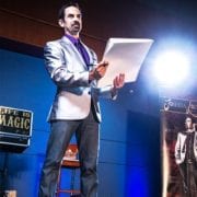
— courtesy McGregor Hall

The New Year Kicks Off With Magic & Mystery As Celebrity Joshua Lozoff Brings His ‘Life Is Magic’ Act To McGregor Hall On Jan. 6, 2018

HENDERSON, N.C. (DECEMBER 28, 2017) — Prepare to have your mind blown on Saturday, Jan. 6, 2018, as McGregor Hall Performing Arts Center in Henderson, N.C., kicks off the New Year with a magical performance theater goers will never forget — Joshua Lozoff: Life Is Magic.

Audience members will likely remember Lozoff from his days acting on the TV show “Cheers” or performing on the big screen in movies like “Clueless.” After his show at McGregor Hall, you’ll never forget Lozoff for his sleight-of-hand mastery.

Lozoff has been studying and sharing magic around the world for nearly 20 years. Today, Lozoff is regarded as one of the top magicians and recently had the honor of being one of only two magicians to receive an invitation to perform at the World’s Fair in Japan. He spent two weeks as a featured performer for the USA Pavilion, entertaining visitors from around the globe.

The award-winning documentary Metacarpus, about the power of the human hand, featured Joshua’s sleight-of-hand mastery alongside an orthopedic surgeon and sign language interpreter.

Joshua’s motto is “Life is Magic,” and he walks his talk by performing everywhere from penthouse suites to the slums of Guatemala City; sharing magic with Fortune 500 CEOs, folks on the street, and everyone in between. Joshua says, “the most beautiful thing about magic is how it appeals to everyone. I can go from a black-tie gala to a backyard barbeque, and everyone has a few moments in time which transcend our ordinary reality; moments of awe, of astonishment, and just a flat-out fun time.”

His performances combine his love for the art of magic, and his fascination with psychology as well as the powers of observation and influence. In one moment, he makes a drawing come to life just by pointing; in the next, he predicts an audience members choices even before they know it themself. “Audience members will be amazed by Joshua’s magic and mental demonstrations,” said Mark Hopper, Vice President of McGregor Hall’s Board of Directors. “We are honored to kick off the New Year at the hall with his caliber of magical, jaw-dropping entertainment.”

Tickets are on sale for $17 or $20 plus sales tax. Group and student rates are available.

Tickets can be purchased directly at the McGregor Hall Box office, which is open Monday through Friday from 1:30 p.m. to 5:30 p.m. The Box Office is located at 201 Breckenridge Street in downtown Henderson. The Box Office can also be reached by phone by calling (252) 598-0662. Tickets can also be purchased online at www.McGregorHall.org by using the secure and trusted purchasing platform, eTix. Online fees apply.

Joshua Lozoff: Life Is Magic is the first of several performances to be held in 2018. The lineup through April includes:
Daddy’s Boys: Broken Promises – January 13, 2018
Al Stewart and The Empty Pockets – February 17, 2018
Karen Peck & New River – February 23, 2018
Masters of Soul – March 3, 2018
Hotel California –  March 16, 2018
The Talleys with Tribute – April 7, 2018
Rod of God – April 14, 2018

For more information on these performances, visit www.McGregorHall.org.

###

(McGregor Hall is an advertising client of WIZS.  This is a press release from McGregor Hall.)