Tag Archive for: #severeweather

H-V Emergency Operations

Severe Weather Preparedness Week 2021

— press release from Brian Short, director Henderson-Vance County Emergency Operations

With pandemic lock downs and a cold, wet winter, most of us are looking forward to spring and warmer weather. However, with spring comes the threat of severe thunderstorms with potential lightning, tornadoes and flash flooding – all of which can develop so rapidly that an advance warning may be impossible.

A great activity to take on while still indoors awaiting the arrival of spring is to get prepared by updating your family emergency plan and supply kit so you are ready should severe weather strike.

To encourage planning and preparation for severe weather, March 7-13, 2021 is Severe Weather Preparedness Week in North Carolina and serves as a reminder to all, the importance of planning for unexpected thunderstorms and tornadoes that could impact our state.

Government agencies, businesses and schools are encouraged participate in the annual statewide tornado drill Wednesday, March 10th, at 9:30 a.m. While exercising social distancing and mask wearing we encourage everyone to practice their severe weather safety plan and seek shelter on the lowest floor of your building and away from windows. Practicing now will allow you to respond quickly when severe weather heads your way.

All residents should take this opportunity to practice what to do in the event that a severe thunderstorm or tornado takes place. Tornadoes and flash floods can develop at a moment’s notice; take time now to prepare and keep you and your loved ones safe.

Keep your home a safe haven this severe weather season and use the following safety tips:

Make Preparation a Priority

When it comes to severe weather, preparation is critical. The ability to recognize threatening conditions, develop a plan and act could help save your life. Thunderstorms include a variety of weather conditions such as tornadoes, straight-line winds, flash floods and hail; this assortment proves the importance of being ready for anything, anytime, anywhere.

North Carolina experiences on average 40 to 50 thunderstorm days per year, but about 10 percent are severe – producing hail at least an inch in diameter, winds of 58 mph or produces a tornado. Lightning is also a danger linked with severe storms and it can strike as far as 10 miles away from the rain area in a thunderstorm. If the sky looks threatening, residents should take shelter immediately and remember, if thunder roars, go indoors! Tornadoes form from powerful thunderstorms and appear as funnel-shaped clouds that reach from a thunderstorm to the ground with winds that can reach 300 miles per hour. Although thunderstorms affect a smaller area than a hurricane or winter storm, if a tornado is produced, damage paths could be more than one-mile-wide and 50 miles long.

Safety Tips

The North Carolina Department of Public Safety and the National Weather Service have teamed to encourage residents to plan and prepare. Due to the variety of severe weather that can take place during spring season, emergency officials recommend the following safety tips:

  • Develop a family emergency plan so each member knows what to do, where to go and who to call during an emergency.
  • Know where the nearest safe room is, such as a basement or interior room away from windows.
  • Know the terms: WATCH means severe weather is possible. WARNING means severe weather is occurring; take shelter immediately.
  • Assemble an emergency supply kit for use at home or in your vehicle. Make sure to include a 3-day supply of non-perishable food and bottled water.
  • If driving, leave your vehicle immediately to seek shelter in a safe structure. Do not try to outrun a tornado in your vehicle and do not stop under an overpass or bridge.
  • If there is no shelter available, take cover in a low-lying flat area.

Make sure you know where to go when disaster strikes.

  • Home – Go to the basement, under stairs or in a bathroom or closet.
  • Work – Go to the basement, if available. If not, stairwells, bathrooms and closets are options too.
  • School – Seek shelter in inside hallways, small closets and bathrooms. Do not retreat to mobile classrooms, gymnasiums, auditoriums and other rooms with a large expanse of roof. Bus drivers should be alert for bad weather on their routes.
  • Outside – Find the closest sturdy shelter or seek shelter in a ditch or low-lying area, and cover your head with your hands. DO NOT get under an overpass or bridge. You are safer in a low, flat location. Watch out for flying debris.
  • In a car – Do not try to outrun a tornado in a car. Pull over, and seek shelter in a building.

Find more information on tornadoes, severe storms and emergency preparedness by visiting the ReadyNC website, www.ReadyNC.org.

Vance County, take time now to prepare; it could make all the difference.

Click this link and print the Family Emergency Plan – https://www.ready.gov/sites/default/files/FamEmePlan_2012.pdf

H-V Emergency Operations

Henderson-Vance Had One Tornado Warning Earlier Monday

100.1 FM ~ 1450 AM ~ WIZS, Your Community Voice ~ Click to LISTEN LOCAL

About 7:48 Monday morning, the National Weather Service issued a tornado warning for Henderson and for portions of north and east Vance County.

Shortly after 8 a.m., the warning for portions of Vance County was cancelled.  However, the simultaneously warned areas in north and west Warren County remained under the warning until it expired at 8:15 a.m.

In an email to Brian Short, Director of Henderson-Vance Emergency Operations, WIZS News asked about ground truth, injuries and damages.

Short wrote back, “As far as I know it was only radar indicated. We did not receive any calls of sightings. To my knowledge we had no damage. We did have a single tree down but it did not impact anything.”

The NWS forecast indicates that the next chance of rain is Tuesday night and Wednesday.  Nothing severe is forecast at this time.

National Weather Service

National Weather Service Raleigh: Latest Briefing


No matter the time of day or the time of year, you can always find the latest briefing from the National Weather Service in Raleigh by following this link (https://www.weather.gov/media/rah/briefing/NWSRaleighLatestBriefing.pdf).

The possibility of severe weather definitely exists for much of the rest of the day.

That said, the latest briefing in the link above, as of this publication at 2:45 p.m. on Thursday, Oct. 31, indicates the most likely time for the WIZS listening area, and for that matter all of central North Carolina, is between 7 p.m. and 10 p.m.

Areas from Raleigh northward are under a level 3 out 5 risk as a cold front pushes through with the threat increasing as you approach the NC/VA border.

The strongest storms will be capable of producing damaging wind gusts. A short-lived and weak tornado is also possible.

Stay tuned to WIZS 1450 AM / 100.1 FM and fb.com/wizsradio for the latest along with www.weather.gov/rah and Raleigh NWS on social media.

National Weather Service

NC Severe Weather Preparedness Week is March 3-9, 2019

-Information courtesy The National Weather Service – Raleigh

The 2019 North Carolina Severe Weather Preparedness Week runs from Sunday, March 3 through Saturday, March 9, 2019.    With the peak of North Carolina’s severe weather season right around the corner, NOW is the time to prepare! 

There are a lot of great resources that you can use to prepare for the severe weather season.  Please take a moment to visit the NWS Raleigh Severe Weather Preparedness Week web site at https://www.weather.gov/rah/2019ncswpw where you’ll find links to our daily severe weather topics and useful severe weather preparedness tips and information.   

In addition to making a severe weather safety plan, we strongly encourage everyone to participate in the Statewide Tornado Drill, which will occur on Wednesday, March 6, 2019, at 9:30 a.m.  Every school, business, workplace, and family across the state is strongly encouraged to participate in this drill. It is important that all schools and businesses are aware of the following important points about the tornado drill:

  • The drill will be broadcast on NOAA Weather Radio and the Emergency Alert System via the Required Monthly Test (RMT).  There will not be an actual Tornado Warning issued.
  • Many NOAA Weather Radio receivers (including the older Midland WR-100 radios that many schools have) do not sound an audible alert for the RMT product; instead, they may have a blinking light on the display to indicate that an RMT was received.  As such, when the RMT for the statewide tornado drill is initiated at 9:30 a.m. on Wednesday, March 6, 2019, there is a chance that your NOAA Weather Radio will not sound an alarm.
  • Since your NOAA Weather Radio may not sound an alarm at the time the RMT is issued, you will want to do one of the following:
    • Manually turn on your NOAA Weather Radio receiver and simply listen to the audio broadcast to hear when the RMT is issued, which will mark the beginning of the statewide tornado drill.
    • Simply plan to start your tornado drill on your own at 9:30 a.m.
  • There will be no follow-up statements issued by the NWS to mark the end of the statewide tornado drill. It will simply be over when your group, school, business, or organization feels that you have adequately practiced your tornado shelter procedures.
  • If there is actual severe weather occurring on the morning of March 6, 2019, the statewide tornado drill will be postponed.  The alternate date for the drill is Friday, March 8, 2019, at 9:30 a.m.
  • This drill and RMT will take the place of the usual weekly NOAA Weather Radio Alert test (RWT).  That is, there will not be a weekly radio test done between 11 a.m. and noon on that day.

Please share this information and encourage all of your friends, family, neighbors, co-workers, and especially all schools, to take the opportunity next Wednesday to participate in the drill, and to take a few moments to learn more about severe weather preparedness. 

Hermine Update (Friday Morning)

Hermine Update (Friday Morning) from the National Weather Service and Vance County Emergency Management Director Brian Short

Late Morning Update:

The director of Vance County Emergency Management, Brian Short, provided an additional email to the one listed below to local emergency preparedness teams, and he said, “Attached is some additional information from North Carolina Emergency Management that is a bit more detailed than what I forwarded out earlier today. Essentially nothing has changed, but have a look in particular to the slide that shows the expected rainfall totals.”  (Click here to view this full update and Tropical Weather Outlook.)

Early Morning Update:

The director of Vance County Emergency Management, Brian Short, said in an email to local emergency preparedness teams this morning by email, “Please see the latest informational briefing from the NWS regarding Tropical Storm Hermine. As you can see, not much has changed from the previous briefing for our area.”

(Click here to view the full briefing)

Short’s email continued, “Officially, we are forecast to receive 2 to 6 inches of rain (though I believe realistically 2 to 3 inches is more likely) with wind gusts of around 30 MPH.

“Our biggest threat we believe will be localized flash flooding particularly in areas that are historically known to flood and possibly a few downed trees. Widespread power outages are not expected, however a few isolated outages may occur.

“At this point we do not believe that we need to convene our Advisory Group or have any sort of formal briefing session, however we will continue to keep everyone informed as the situation matures.

“Our office will remain poised to implement additional emergency protection if it should become necessary.”

Granville Vance Tornado Path

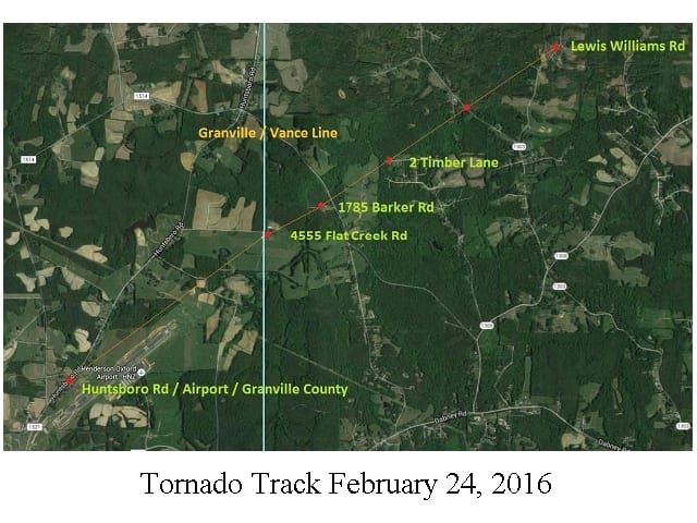
Director of Emergency Operations for Henderson and Vance County Brian Short provided the picture below to WIZS News by email.

In his email, he wrote, “(Wednesday’s) tornadoes caused significant damage in the northern portion of Vance County. While we believe at this time that we had three separate tornadoes in total, I have attached some locational data showing four points that we feel strongly are tornado touchdowns in Vance County. This helps to define the path of the tornado that caused the damage in the northern part of the County.”

According to what Short is saying, there were apparently three separate tornadoes believed to have been in Vance County on Wednesday, while the picture shows the path of a single tornado which it is believed caused the damage in northern Vance County.  The path pictured is of the tornado which caused so much damage in the Huntsboro community in Granville County before moving into Vance County and touching down as many as four more times.

tornado track 022416

4 Confirmed Tornado Touchdowns in Vance County

Director of Emergency Management for Henderson and Vance County told WIZS News, “We have at least four confirmed tornado touchdowns in Vance County.”

He said he thought it was all from the same tornado. “The weather service will have to confirm that from doppler imaging. They are also technically going to have to confirm that it’s tornadic damage, but I’ve seen enough to know that it is.”

Short said the weather service would be coming in tomorrow or the next day to make that determination.

There are no known deaths or injuries to report in Vance County.

Short said the four touchdowns caused significant damage. He said there were a few isolated power outages “in the Hicksboro, Williamsboro area, which is where most of the damage is.”

There are no roads closed at this time. Emergency crews cleared several downed trees really quickly, according to Short.

Based on our own observations at WIZS, these tornado touchdowns north of Henderson would have occurred right around 5:00 P.M. Wednesday. Additionally, there is an amateur video clip that has been shown several times on WTVD-TV that is supposedly of a tornado just north of Henderson, and if so, this would be in line with what Short is reporting. This stems from the first of three tornado warnings issued for Vance County on Wednesday.

The second and third tornado warnings for Vance County involved mostly areas south and east of the City of Henderson, down towards Bearpond, Kittrell and east towards Cokesbury. When asked if anything materialized from the warnings for the southern part of Vance County, Short said, “Not that I know of, but we had multiple people going in multiple directions, and I have not talked to all of them yet.”

In neighboring Granville County, near Huntsboro, which is not far from the Henderson-Oxford Airport, multiple structures were damaged.  One house was completely destroyed, while adjacent houses received heavy damage.  A local dairy farmer sustained heavy property damage, including two silos as well as equipment and other structure damage.  WIZS News spoke directly with a person on the scene in Huntsboro.  He reported the dairy farmer had not lost any of his cows and that he was observing the aftermath of the storm firsthand while speaking with us.

Severe Weather Threat

Tornado Watch in effect until 7 P.M. link

Area Schools Dismissing Early.  Most in the Henderson-Vance and Granville area dismissing at 11:30 A.M.  (See WIZS Facebook Page)

National Weather Service link

NWSRaleighLatestBriefing (022416 morning) — as supplied by Brian Short, Director of Emergency Operations for Henderson and Vance County