

Updated Friday, Sept. 14 at 4 p.m.
WIZS will be bringing you updates on Hurricane Florence as new information is received. Please check the WIZS website, Facebook page and listen live to WIZS 1450 AM and 100.1 FM for updates. The latest briefing from the National Weather Service can be found by clicking here.
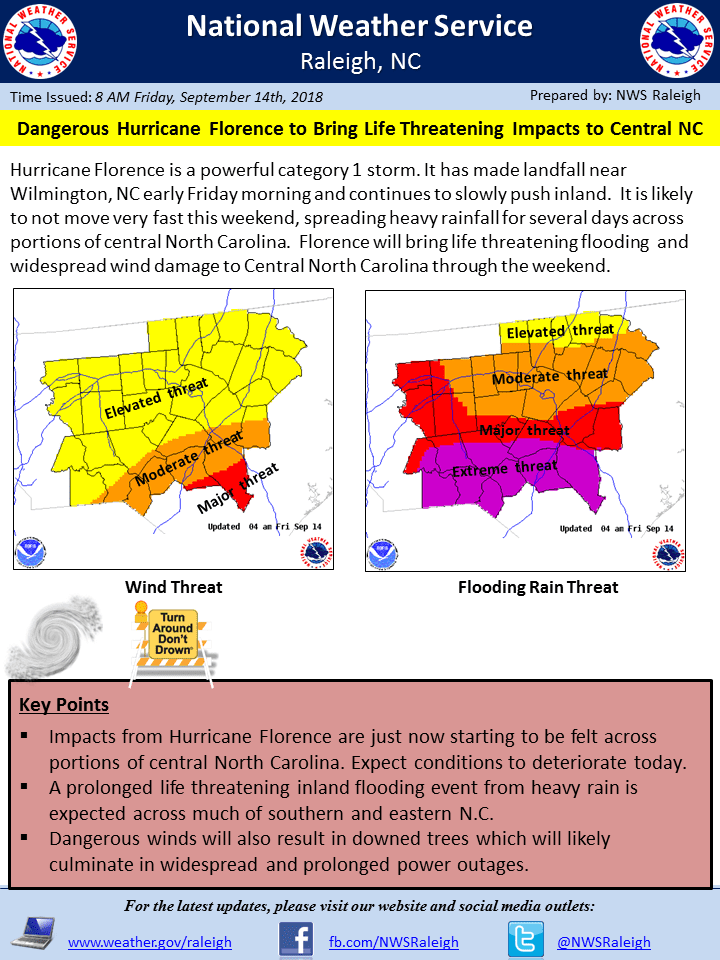
Hurricane Florence has made landfall and continues to slow. It is expected to slowly meander southwest into and across South Carolina through the weekend.
PRIMARY THREAT: Catastrophic flash and eventually river flooding is expected to persist through the weekend and into early next week. Strong sustained winds and gusts persisting into the weekend. Strongest gusts expected across the southeastern coastal plain of NC. Risk for short-lived and weak tornadoes as the rain bands push ashore this evening through Saturday afternoon. This event is now on-going. Please heed any evacuation orders that have been issued and continue to monitor the forecast for updates.
Three Key Points
1. Wind impacts continue from Hurricane Florence today, but the primary flooding threat is just beginning as the eye continues to stall just inland.
2. Initial heavy rainfall will cause Flash Flooding (ongoing) with prolonged moderate to major river flooding continuing into next week, especially across southern and eastern N.C.
3. Travel will likely become more treacherous today and tonight thanks to flooding. Dangerous winds coupled with saturated ground will also result in downed trees which will likely culminate in widespread and prolonged power outages.
——————————————————————————————————————————————————
Updated Friday, Sept. 14 at 11 a.m.
Presently, Vance County remains under a local State of Emergency.
We have one active emergency shelter located at the former Eaton Jonson Middle School building in Henderson. The shelter currently has 40 occupants and we have noticed the numbers increasing this morning. We plan to leave the shelter open throughout the day today. We may decide to close the shelter later this evening but, worst-case scenario, we should be safe to close it tomorrow morning.
Our pet shelter also remains open. Presently we are sheltering one animal whose owner is in the shelter at Eaton Johnson Middle School.
We are receiving a few calls reporting downed trees and other minor storm-related calls but nothing major so far.
According to Duke Energy, as of now, Vance County has a total of 1,052 customers without power. This is down from over 2,200 overnight.
Our E-911 center remains overstaffed and the Emergency Operations Center remains activated with EM staff only. The EOC will close once we stand down the emergency shelter.
We still anticipate gusty winds and periods of hard rain today as bands from the hurricane move through our area.
Everyone, please stay safe.
Updated Friday, Sept. 14 at 8:30 a.m.

_______________________________________________________________________________________
Updated Friday, Sept. 14 at 8 a.m.
Hurricane Florence has been downgraded to a category 1 storm with 90 mph winds along parts of the coast.
Vance County has experienced some periods of heavy rain at times, as well as some gusts of 35 mph but, so far, we have faired pretty well.
Presently we have 34 people in our emergency shelter at the former Eaton Johnson Middle School building on Beckford Dr. The shelter will remain open today.
We remain under a local state of emergency but, so far, we have not experienced anything major as a result of the storm.
We will continue to forward along additional updates as they are received.