Tag Archive for: #hendersonvancecountyemergencyoperations

National Weather Service

It’s North Carolina Hurricane Preparedness Week. Are You Ready?

-Information courtesy Henderson-Vance County Emergency Operations

The Atlantic hurricane season begins on June 1 of each year and ends on November 30. Tropical cyclones are among nature’s most powerful and destructive phenomena. If you live in an area prone to tropical cyclones, you need to be prepared. Even areas well away from the coastline can be threatened by dangerous flooding, destructive winds and tornadoes from these storms. The National Hurricane Center issues watches, warnings, forecasts, and analyses of hazardous tropical weather.

May 5 through May 11, 2019, is Hurricane Preparedness Week in North Carolina, as well as nationally. The Vance County Office of Emergency Operations wants to make sure that you and your family are prepared for whatever this season brings our way.

The 2019 Atlantic hurricane season is forecast to be slightly below average due to a relatively high likelihood of a weak El Nino coupled with slightly lower sea surface temperatures, according to a report released by Colorado State University. Their predictions for this season include 13 named storms, with 5 becoming hurricanes and 2 expected to become major hurricanes of category 3 status or higher.

Forecasters at North Carolina State University are forecasting a near average season with similar expectations and a range of 13 to 16 names storms.

“The time to prepare is now, well out in front of hurricane season,” said Brian K. Short, Director of Emergency Operations for Vance County. Keep in mind that it only takes one storm to cause significant impact. Communities and individuals are expected to be self-sufficient for a minimum of 72 hours (3 days) following the impact of a hurricane. “If the impact is severe enough, it could potentially take outside help that long to get here,” Short said. “By taking the time to gather up a few basic necessities now, you will enable your family to weather the storm and the aftermath until help can arrive.”

In the event that a storm should threaten our area, the Vance County Emergency Operations staff will use all available means to get important information out and will keep the public informed of our preparedness activities. Like us on Facebook to stay up to date on severe weather and coordination activities.

Smartphone users can also download a free app from ReadyNC.org. This app provides a great deal of information regarding storm preparedness as well as current road conditions, local weather, power outages and storm shelters that are open just to name a few. Follow the link below to get this free app.

https://www.readync.org/EN/DOWNLOADAPP.html

For more information about how you and your family can prepare for severe weather, including hurricanes, visit our website at: https://www.vancecounty.org/em.

While you’re there, be sure to visit our community alert and notification section to sign up for CODE RED, our emergency alert system. NOTE: if you have a landline phone you are most likely already in the CODE RED system. Please add your cell phone if you would like to receive real-time local alerts on your mobile phone or device.

You may also visit Vance County Emergency Operations on Facebook or call our office at 252-438-8264 for more information.

The 2019 tropical storm names for the Atlantic region include Andrea, Barry, Chantal, Dorian, Erin, Fernand, Gabrielle, Humberto, Imelda, Jerry, Karen, Lorenzo, Melissa, Nestor, Olga, Pablo, Rebekah, Sebastian, Tanya, Van and Wendy.

Recommended Family Preparedness Items

The best time to assemble a three-day emergency supply kit is well before you will ever need it. Most people already have these items around the house and it is a matter of assembling them now before an evacuation or State of Emergency order is issued. Stocking up now on emergency supplies can add to your family’s safety and comfort during and after a disaster. Store enough supplies for at least three days, preferably seven days, in one place.

Start with an easy to carry, watertight container – a large plastic trash can will do, or line a sturdy cardboard box with a couple of trash bags. Next, gather up the following items and place them in your kit:

Essentials

 Water – 1 gallon per person per day (a week’s supply of water is preferable)

 Water purification kit or bleach

 First aid kit and first aid book

 Pre-cooked, non-perishable foods, such as canned meats, granola bars, instant soup & cereals, etc.

 Baby supplies: formula, bottle, pacifier, soap, baby powder, clothing, blankets, baby wipes, disposable diapers, canned food and juices

 Non-electric can opener

 Anti-bacterial hand wipes or gel

 Blanket or sleeping bag per person

 Portable radio or portable TV and extra batteries

 Flashlight and extra batteries

 Essential medications

 Extra pair of eyeglasses

 Extra house and car keys

 Fire extinguisher – ABC-type

 Food, water, leash and carrier for pets

 Cash and change

 Seasonal change of clothing, including sturdy shoes

Sanitation Supplies

 Large plastic trash bags for waste, tarps and rain ponchos

 Large trash cans

 Bar soap, shampoo and liquid detergent

 Toothpaste and toothbrushes

 Feminine hygiene supplies

 Toilet paper

 Household bleach

 Rubber gloves

 Don’t forget your pets when getting prepared!!!

H-V Emergency Operations

Hurricane Florence Updates – Sept. 14

Updated Friday, Sept. 14 at 4 p.m.

WIZS will be bringing you updates on Hurricane Florence as new information is received. Please check the WIZS websiteFacebook page and listen live to WIZS 1450 AM and 100.1 FM for updates. The latest briefing from the National Weather Service can be found by clicking here

-Information courtesy Brian K. Short, Director of Emergency Operations, Henderson-Vance County Emergency Operations and the National Weather Service

Hurricane Florence has made landfall and continues to slow. It is expected to slowly meander southwest into and across South Carolina through the weekend.

PRIMARY THREAT: Catastrophic flash and eventually river flooding is expected to persist through the weekend and into early next week. Strong sustained winds and gusts persisting into the weekend. Strongest gusts expected across the southeastern coastal plain of NC. Risk for short-lived and weak tornadoes as the rain bands push ashore this evening through Saturday afternoon. This event is now on-going. Please heed any evacuation orders that have been issued and continue to monitor the forecast for updates.

Three Key Points

1. Wind impacts continue from Hurricane Florence today, but the primary flooding threat is just beginning as the eye continues to stall just inland.

2. Initial heavy rainfall will cause Flash Flooding (ongoing) with prolonged moderate to major river flooding continuing into next week, especially across southern and eastern N.C.

3. Travel will likely become more treacherous today and tonight thanks to flooding. Dangerous winds coupled with saturated ground will also result in downed trees which will likely culminate in widespread and prolonged power outages.

——————————————————————————————————————————————————

Updated Friday, Sept. 14 at 11 a.m.

Overall, Vance County seems to be weathering the storm pretty well.

Presently, Vance County remains under a local State of Emergency.

We have one active emergency shelter located at the former Eaton Jonson Middle School building in Henderson. The shelter currently has 40 occupants and we have noticed the numbers increasing this morning. We plan to leave the shelter open throughout the day today. We may decide to close the shelter later this evening but, worst-case scenario, we should be safe to close it tomorrow morning.

Our pet shelter also remains open. Presently we are sheltering one animal whose owner is in the shelter at Eaton Johnson Middle School.

We are receiving a few calls reporting downed trees and other minor storm-related calls but nothing major so far.

According to Duke Energy, as of now, Vance County has a total of 1,052 customers without power. This is down from over 2,200 overnight.

Our E-911 center remains overstaffed and the Emergency Operations Center remains activated with EM staff only. The EOC will close once we stand down the emergency shelter.

We still anticipate gusty winds and periods of hard rain today as bands from the hurricane move through our area.

Everyone, please stay safe.


Updated Friday, Sept. 14 at 8:30 a.m.

-Information courtesy Brian K. Short, Director of Emergency Operations, Henderson-Vance County Emergency Operations and the National Weather Service

_______________________________________________________________________________________

Updated Friday, Sept. 14 at 8 a.m.

Hurricane Florence has been downgraded to a category 1 storm with 90 mph winds along parts of the coast.

Vance County has experienced some periods of heavy rain at times, as well as some gusts of 35 mph but, so far, we have faired pretty well.

Presently we have 34 people in our emergency shelter at the former Eaton Johnson Middle School building on Beckford Dr. The shelter will remain open today.

We remain under a local state of emergency but, so far, we have not experienced anything major as a result of the storm.

We will continue to forward along additional updates as they are received.

H-V Emergency Operations

Former Eaton Johnson Middle School to Open As Emergency Shelter

-Information courtesy Brian K. Short, Director of Emergency Operations, Henderson-Vance County Emergency Operations

In preparation for Hurricane Florence, Vance County will be opening an emergency shelter at the former Eaton Johnson Middle School building, located on Beckford Drive in Henderson at 5 p.m. today. Please do not arrive prior to that time and please eat before you arrive as food may not be available at typical meal times.

If you have a pet that you wish to shelter, you will need to take them to the Vance County Animal Shelter, located on Brodie Road in Henderson. Your pet will remain there and you will report to the emergency shelter at the school. You and your pet will be reunited after the storm.

Please remember to bring essential items with you, such as necessary medications, a change of clothes, toiletry items, a pillow and blanket, snacks and other comfort items. These items will not be provided to you, so pack smart. If you are a resident with special needs, you will need to bring essential, life-sustaining items with you to the shelter and your caregiver will need to remain in the shelter with you through the storm.

NO WEAPONS OF ANY KIND WILL BE ALLOWED IN THE SHELTER AND LAW ENFORCEMENT WILL BE PRESENT.

This is an emergency shelter only that is being established for the storm and it will promptly close as soon as the winds subside and conditions are safe to do so.

H-V Emergency Operations

Hurricane Florence Updates – Tues. Sept. 11

Updated Tuesday, Sept. 11 at 12:30 p.m.

WIZS will be bringing you updates on Hurricane Florence as new information is received. Please check the WIZS websiteFacebook page and listen live to WIZS 1450 AM and 100.1 FM for updates throughout the week. The latest briefing from the National Weather Service can be found any time by clicking here.

Information is provided courtesy Brian K. Short, director of Henderson-Vance County Emergency Operations.

(Click here for WIZS audio of this Story.)

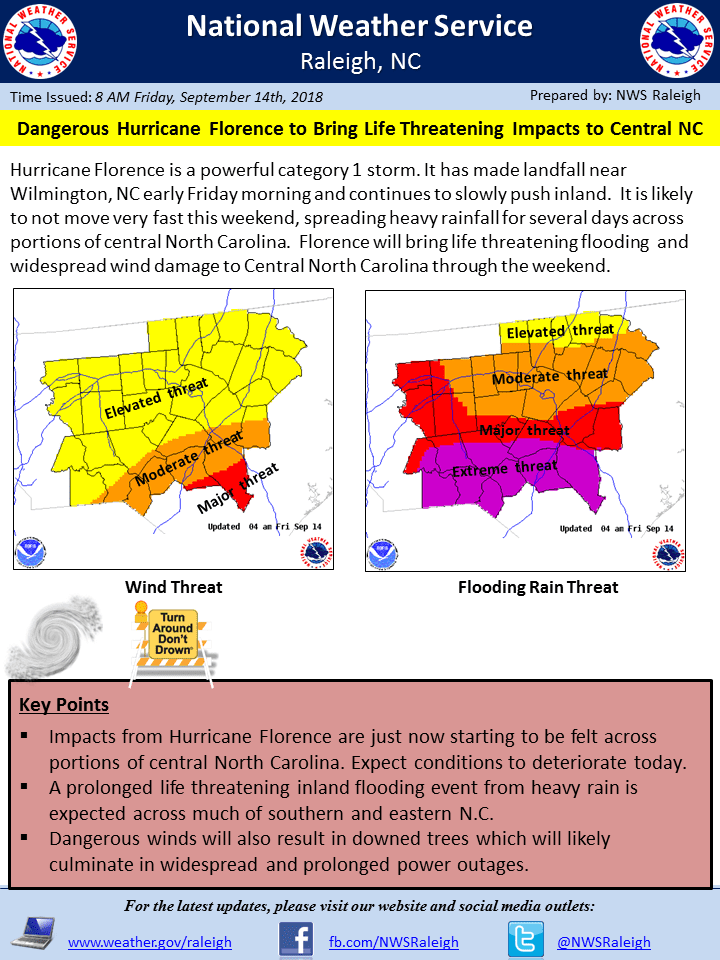
With Hurricane Florence now only a few days away from us, our preparation efforts are now in full swing. As you can see from the latest weather briefing from the National Weather Service, this is a powerful storm that is expected to bring tremendous rainfall and damaging winds to our area of NC.

Widespread power outages are likely due to falling trees and wind. There is tremendous potential for widespread flooding and flash flooding as well. At this time, we are anticipating the tropical storm force winds to reach us late Thursday evening, but that could certainly change as the system gets closer to us.

We will be having a responder briefing which will include City and County government personnel on the apparatus floor of Henderson Fire Department Station 1 located at 211 Dabney Drive in Henderson. The briefing will begin at 3 p.m. tomorrow (Wednesday). Representatives from all responder agencies are strongly encouraged to attend.

Additionally, we are planning on recommending that a local Proclamation of a State of Emergency be put in place at the conclusion of tomorrows responder briefing. It will remain in place throughout the storm.

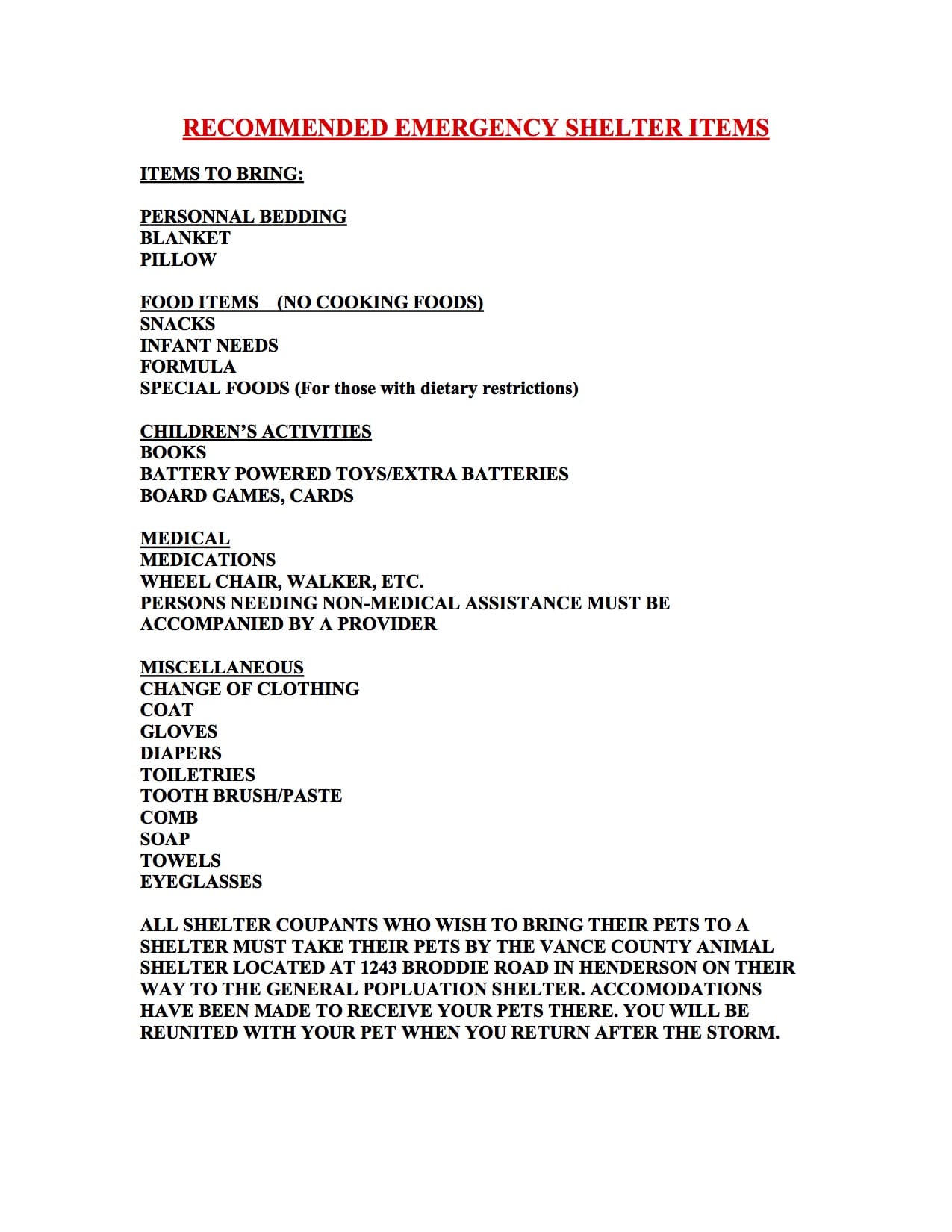
At this time we are planning to open a single, centrally located shelter at Eaton Jonson’s Middle School, located at 500 N. Beckford Drive in Henderson. We may adjust the opening time slightly as the storm gets closer to us but for now, we will open the shelter at 9 a.m. on Thursday. Below is a list of shelter items that every shelter occupant MUST bring with them to the shelter. We will do limited feeding at the shelter but will not be supplying personal items or any other items that occupants might have forgotten, so please refer to the list and read it carefully.

We are particularly concerned for residents who live in mobile/manufactured homes. We are expected to have tropical storm force winds in our area, which can cause significant damage, especially to smaller structures. We are therefore encouraging those residents who live in mobile homes to report to the shelter.

If you are a resident that does not have a way to the shelter, then please reach out to our office and we will do our best to arrange it with KARTS. They are willing to provide limited transportation services if anyone absolutely does not have another way to get there. We are encouraging residents who do not have transportation of their own to reach out to family members and neighbors first. This will ensure that they are available to those who absolutely do not have any other means of travel. If you have a need to transport a pet using KARTS, they will not transport it unless it is secured in an animal crate.

For those who have pets they wish to bring to the shelter, they must bring their pets to the Vance County Animal Shelter located on Brodie Road in Henderson. You will need to leave your pet there and then report to the general population shelter. You will be reunited with your pet after the storm. If you have a crate for your pet you must bring it with you to the shelter.

We will also be announcing our shelter openings utilizing our CODE RED community alert system, radio, print and social media, so please follow us on Facebook.

I cannot emphasize enough how important it is to take the time to prepare before the storm’s arrival. There is still time, so please use the attached as a guide. Remember, if this is a significant impact across the state (and it is believed that will be the case,) it could take days for any significant help to reach us. Therefore we strongly encourage everyone to be 72 hours self- sufficient.

Further updates will be forwarded along as they are received.

National Weather Service

Hurricane Florence Updates

Updated Monday, Sept. 10 at 11 a.m.

WIZS will be bringing you updates on Hurricane Florence as new information is received. Please check the WIZS website, Facebook page and listen live to WIZS 1450 AM and 100.1 FM for updates throughout the week. Information is provided courtesy Brian K. Short, director of Henderson-Vance County Emergency Operations.

Confidence continues to increase that Hurricane Florence will have a significant impact on NC.

Henderson-Vance County Emergency Operations continues to monitor the storm very closely and we are actively making plans to implement emergency protective measures such as sheltering and the issuance of a local State of Emergency should it become necessary.

We are continuing to coordinate with local and State response partners and will be participating in a series of conference calls with State Emergency Management over the coming days.

Make no mistake, this is a storm that all of us should take VERY seriously. The time to prepare for this storm is at hand if you have not already begun. Below is a list of recommended family preparedness items that we strongly recommend everyone has on hand prior to the storm’s impact. Remember, it could take as long as 72 hours for help to reach you if our impact is significant and damage is widespread.

Remember to monitor the storm’s progress closely as it heads our way and do not take its approach lightly. We will continue to forward along additional updates as they are received.

Recommended Family Preparedness Items

The best time to assemble a three-day emergency supplies kit is well before you will ever need it. Most people already have these items around the house and it is a matter of assembling them now before an evacuation or State of Emergency order is issued. Stocking up now on emergency supplies can add to your family’s safety and comfort during and after a disaster. Store enough supplies for at least three days, preferably seven days, in one place.

Start with an easy to carry, watertight container – a large plastic trash can will do, or line a sturdy cardboard box with a couple of trash bags. Next, gather up the following items and place them in your kit:

Essentials

  • Water – 1 gallon per person per day (a week’s supply of water is preferable)
  • Water purification kit or bleach
  • First aid kit and first aid book
  • Pre-cooked, non-perishable foods, such as canned meats, granola bars, instant soup & cereals, etc.
  • Baby supplies: formula, bottle, pacifier, soap, baby powder, clothing, blankets, baby wipes, disposable diapers, canned food and juices
  • Non-electric can opener
  • Anti-bacterial hand wipes or gel
  • Blanket or sleeping bag per person
  • Portable radio or portable TV and extra batteries
  • Flashlight and extra batteries
  • Essential medications
  • Extra pair of eyeglasses
  • Extra house and car keys
  • Fire extinguisher – ABC-type
  • Food, water, leash and carrier for pets
  • Cash and change
  • Seasonal change of clothing, including sturdy shoes

Sanitation Supplies

  • Large plastic trash bags for waste, tarps and rain ponchos
  • Large trash cans
  • Bar soap, shampoo and liquid detergent
  • Toothpaste and toothbrushes
  • Feminine hygiene supplies
  • Toilet paper
  • Household bleach
  • Rubber gloves
  • Don’t forget your pets when getting prepared!!!
——————————————————————————————————————————————————

Updated Monday, Sept. 10 at 10 a.m.

As most of you are aware, Tropical Storm Florence is making its way across the Atlantic with the overwhelming majority of the forecast models bringing it in our direction the middle of the week. Additionally, it is forecast to be a major Hurricane at the time of landfall. Normally at this stage of a tropical system’s approach, we are largely watching it and will begin making decisions and initiating our preparedness activities as it gets a little closer. However, with the models essentially lining up as they are it only makes sense to accelerate some of our efforts.

NC Emergency Management will begin conducting conference calls on Monday with all the counties in our area if our situation does not improve prior to that point.

Our office will also begin our planning efforts on Monday and will be coordinating with our local and state response partners as the week goes on. Even as far away as the storm currently is, given the relative certainty of the forecast tracks, we are advising everyone to begin some basic preparedness activities of their own.

Remember, even if Florence does not pay us a visit, the Atlantic basin is alive with activity at present with system after system lining up. The National Weather Service will be issuing storm updates through the day and every day until the storm is no longer a threat. We will forward those updates along as they are received. Remember the time to prepare is now.


Updated Friday, Sept. 7 at 5 p.m.

Florence, churning out in the Atlantic, has weakened to tropical storm status but is expected to gain strength again over the weekend.

According to Brian K. Short, director of Henderson-Vance County Emergency Operations, local residents need to keep an eye on the forecast and be prepared for inclement weather.

“Some of the current models are showing Tropical Storm Florence could have an Eastern US impact towards the end of next week, but it is still too early to call,” said Short. “We will keep an eye on it moving forward and will continue to push out additional updates as they are received.”

The National Weather Service has released a list of five things that you need to know now:

1) It’s too early to predict exactly where Florence will move beyond early next week.

2) Concerns for at least some effects on the U.S. are growing, but it is far too early to give specifics.

3) It is never too early to PREPARE! What should be in your hurricane kit? https://www.ready.gov/build-a-kit

4) Know your risk! Find out if you live in a flood zone or if your home would be unsafe during a hurricane.

5) Be cautious of the information you see on social media. Avoid sources that create hype or promise forecasts beyond the limits of current science.